Need help with booking? Send us a message.
Experience the legendary Annapurna Circuit Trek, crossing the spectacular Thorang La Pass (5,416). Trek through diverse landscapes, traditional; mountain village and breathtaking Himalayan scenery while enjoying unforgettable views of Annapurna, Dhaulagiri and Manaslu.
The Annapurna Circuit isn't just a trek, it's a journey that completely circles one of the world's most spectacular mountain massifs. Over two to three weeks, you'll walk from subtropical valleys at 800 meters to the Thorong La Pass at 5,416 meters, crossing from one side of the Annapurna range to the other through landscapes that change so dramatically you'll wonder if you're still in the same country.
This is the trek that put Nepal on the adventure travel map back in the 1970s. While other routes have gained popularity, the Annapurna Circuit remains special because of its sheer diversity. You start in rice paddies and end in high-altitude desert. You walk through Hindu villages in the south and Tibetan Buddhist communities in the north. You experience monsoon-fed forests and rain shadow aridity in a single journey.
But here's what most guidebooks don't tell you—the classic Annapurna Circuit has changed significantly in recent years. Roads now reach many sections that were once foot-traffic only. The experience has evolved, and knowing how to navigate these changes makes the difference between a good trek and an exceptional one.
That's where Higher Path Treks comes in. We've been guiding the Annapurna Circuit since before the roads arrived, and we know how to craft an itinerary that maximizes the classic circuit experience while adapting to modern realities. We'll get you off those dusty roads and onto the trails that still capture the magic that made this trek legendary.
Let's talk about what makes the Annapurna Circuit different from other major treks in Nepal.
Complete diversity in one journey: The circuit offers perhaps the most varied trekking experience on Earth. You walk through every climatic zone from tropical to arctic. The cultural diversity matches the geographic variety—Hindu lowlands transition to Tibetan Buddhist highlands, with distinct communities maintaining their traditional ways of life at each elevation.
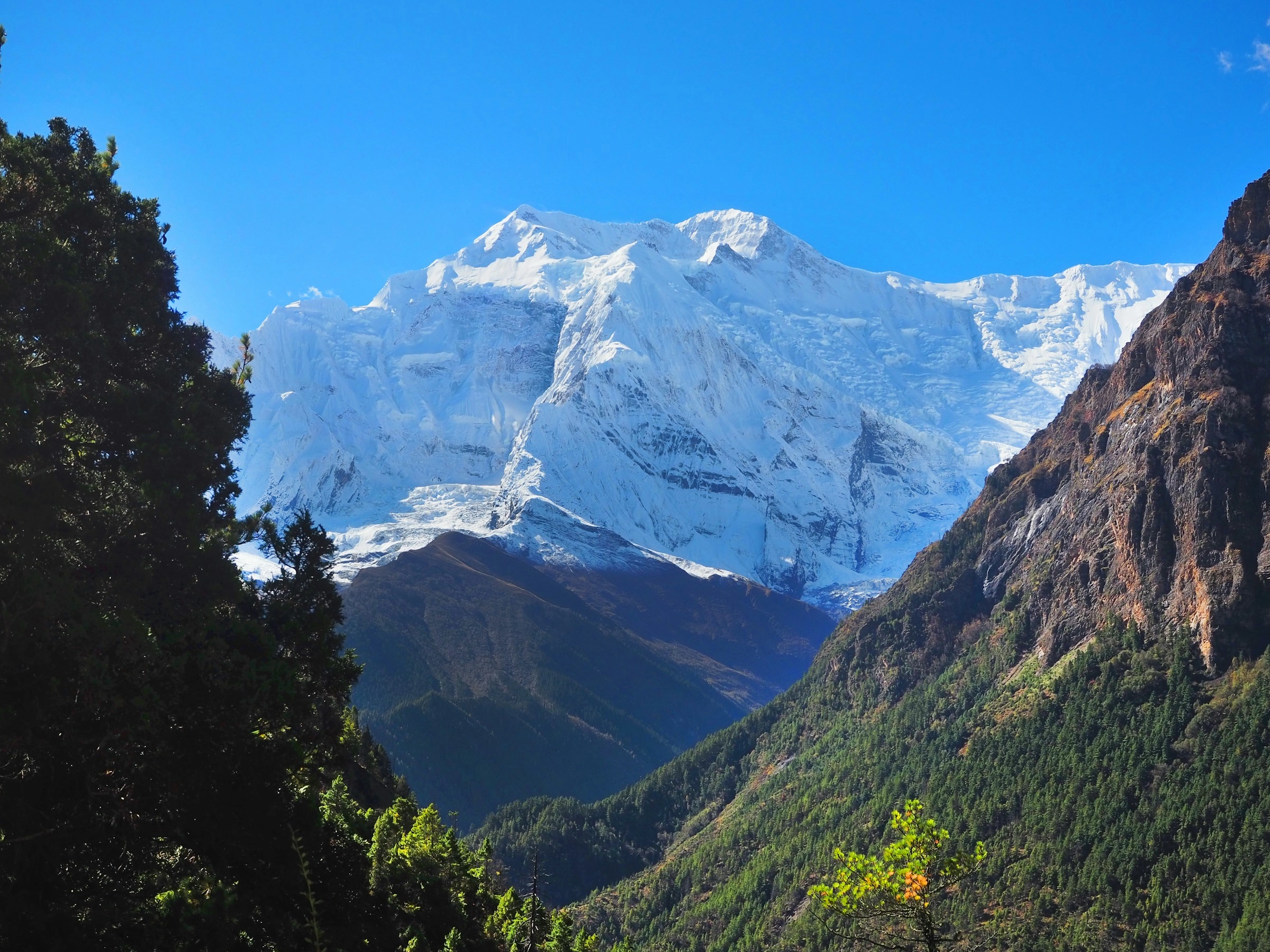
The rain shadow transition: The Annapurna massif creates a dramatic rain shadow effect. The southern approach receives heavy monsoon rains, supporting lush forests and agriculture. Once you cross Thorong La Pass and descend into Mustang region, you enter high-altitude desert where annual rainfall measures in inches rather than feet. Walking from one to the other in a few days is remarkable.
Thorong La Pass challenge: At 5,416 meters, Thorong La is one of the world's highest trekking passes. It's not technical, but it's a genuine high-altitude challenge that tests your preparation and acclimatization. Standing at the top with 360-degree mountain views makes every difficult step worth it.
Cultural immersion depth: Two to three weeks on the trail means you're not just passing through villages—you're experiencing them. You eat with families, learn local customs, witness daily life, and understand how Himalayan communities function. This depth of cultural interaction is hard to find on shorter treks.
The Kali Gandaki Gorge: The descent through the world's deepest gorge, flanked by Dhaulagiri (8,167m) and Annapurna I (8,091m) rising from the valley floor, is geologically and visually stunning. Walking this ancient trade route connects you to centuries of history.
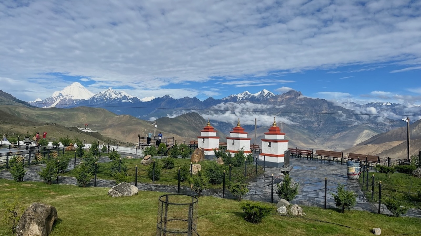
Pilgrimage significance: The circuit includes sacred sites like Muktinath, where Hindu and Buddhist pilgrims have traveled for centuries. You're walking not just a trekking route but a pilgrimage path with deep spiritual meaning.
Timing significantly impacts your circuit experience.
Autumn is peak season for excellent reasons. After monsoon clears in September, you get stable weather, clear skies, and comfortable temperatures.
September can still have occasional monsoon tail-end precipitation, but generally conditions are good. October offers ideal trekking weather—perfect temperatures, crystal-clear mountain visibility, stable weather patterns. November gets colder, especially at Thorong La, but remains excellent for trekking.
The post-monsoon clarity makes mountain views spectacular. The air has been washed clean by months of rain, creating visibility that makes distant peaks seem impossibly close.
Considerations: This is the busiest season. Lodges fill quickly, especially in Manang and around Thorong La. Book ahead or have backup plans. Despite crowds, it's still far less congested than routes like Everest Base Camp Trek
Spring rivals autumn for conditions. March through May offers stable weather and the famous rhododendron blooms in lower sections.
March can be cold at high altitude with possible snow at Thorong La, but it's manageable with proper gear. April is probably the best spring month—warm enough to be comfortable, flowers blooming, excellent visibility. May gets quite warm in lower sections (sometimes uncomfortably hot), but high altitude remains pleasant.
Lower elevation rhododendron forests bloom spectacularly in spring—hillsides covered in red, pink, and white flowers create stunning landscapes.
Considerations: Slightly fewer trekkers than autumn, though still busy in April. Weather is generally stable but slightly less predictable than October.
Monsoon makes the circuit difficult but not impossible. The western side (Mustang region) is in the rain shadow and remains relatively dry. The eastern approach and southern sections receive heavy rain.
Some adventurous trekkers still complete the circuit during monsoon, accepting reduced visibility and wet conditions for extreme solitude. Leeches are common in lower forests. Landslides can block trails. Mountain views hide behind clouds most days.
If trekking during monsoon, consider going clockwise (starting in Jomsom, ending in Besisahar) to cross Thorong La early before monsoon weather fully develops.
Winter circuit trekking is possible but demands serious preparation. Thorong La can be impassable due to heavy snow. Temperatures drop to -20°C or lower at high altitude. Some lodges close in upper sections.
That said, winter offers unique rewards: total solitude, pristine snow-covered landscapes, the clearest skies of the year. Just be prepared with proper winter gear, flexible schedule, and acceptance that reaching Thorong La might not be possible.
The Annapurna Circuit is challenging—longer and higher than treks like Annapurna Base Camp Trek.
Duration: 12-21 days depending on route variations and pace. That's two to three weeks of consecutive trekking. Your body needs endurance beyond basic fitness.
Altitude: You reach 5,416m at Thorong La Pass. Extended time above 3,000m means altitude sickness is a significant risk. Proper acclimatization is crucial—spend adequate time in Manang, ascend gradually, and recognize symptoms early.
Daily trekking time: Typically 5-8 hours per day. Pass day can be 8-10 hours. The walking itself isn't technical, just sustained effort at altitude.
Terrain: Well-maintained trails with some steep sections, thousands of stone steps, suspension bridges, and rocky paths. Not technical, but physically demanding.
Weather variability: You trek through multiple climate zones experiencing everything from subtropical heat to freezing high-altitude conditions. Be prepared for dramatic temperature swings.
Physical preparation: Start training 2-3 months before. Focus on cardiovascular fitness (running, cycling, hiking), leg strength (stairs, lunges, squats), and hiking with a weighted pack on weekends. Previous multi-day trekking experience is highly recommended.
Mental preparation: Two to three weeks is a long time to be trekking. Mental toughness matters as much as physical fitness. You'll have difficult days where you question your decisions—that's normal. Push through.
The Annapurna Circuit is complex with route variations, accommodation choices, and road vs. trail decisions. Having an experienced team makes a significant difference.
We've guided the circuit countless times and know every variation. We balance classic trekking sections with strategic vehicle use to maximize trail time while avoiding the worst road walking. Our itineraries follow proper acclimatization schedules, building in adequate time in Manang before attempting Thorong La.
Our circuit guides know this route intimately—every village, every shortcut, every viewpoint. More importantly, they understand altitude sickness, monitor trekkers carefully, and make conservative safety decisions. They're certified with wilderness first aid training and high-altitude rescue protocols.
Pass day requires precise logistics—early starts, proper timing, weather monitoring, and backup plans. We've successfully guided hundreds of trekkers over Thorong La and know what it takes to get people safely across.
Not all circuit lodges are equal. We've identified the best options at each stop—lodges with cleaner rooms, better food, more reliable hot water, and hospitable owners. This matters when you're spending two to three weeks on trail.
Bad weather at Thorong La? Need an extra acclimatization day? Someone injured or sick? We adjust plans as needed. Flexibility is built into our approach because mountains don't follow schedules and neither should safety decisions.
Our guides have relationships with communities along the circuit. They speak local languages, understand customs, and facilitate genuine cultural interactions. You're not just walking through villages—you're experiencing them through local eyes.
We employ local guides and porters, use locally-owned lodges, follow leave-no-trace principles, and support community development projects. When you trek with us, you're contributing to sustainable tourism that benefits mountain communities.
The circuit has well-established lodge infrastructure, but comfort levels vary.
Lodges here are comfortable with decent amenities—private or semi-private rooms, hot showers (for extra fee), varied menus. Food is fresh and well-prepared, offering both Nepali standards (dal bhat, momos) and tourist favorites (pasta, pizza, burgers).
Accommodation remains good. Manang especially has numerous lodges competing for business, meaning decent quality. Hot showers available, electricity for charging devices (usually for a fee), and restaurants with proper menus.
Food quality stays high in Manang—it's a major stop with multiple bakeries, restaurants, and shops. You can find international food, good coffee, and even alcohol if you want to celebrate before the pass.
Lodges become more basic. Rooms are simple, bathrooms are shared (and increasingly cold), hot water is expensive or unavailable. Electricity is limited (solar power with restricted hours).
Food menus shrink. Dal bhat becomes the most economical choice with unlimited refills. Other options exist but cost more since everything must be carried or flown up.
Accommodation quality improves after crossing the pass. Muktinath, Kagbeni, Jomsom, and villages down the Kali Gandaki have good lodges. Food variety returns, hot showers become available, and comfort levels increase.
You'll eat dal bhat frequently—it's nutritious, provides sustained energy, and includes unlimited refills. Locals eat it twice daily, and there's good reason—it works for fueling long trekking days. First week it's interesting, second week you might be tired of it, but it genuinely provides what your body needs at altitude.
This is the primary health concern. Acute Mountain Sickness (AMS) can affect anyone regardless of fitness.
Prevention strategies:
Treatment: If symptoms are mild, rest at current altitude. If symptoms worsen or don't improve with rest, descend immediately. Descent is the only reliable cure for serious altitude problems.
Your guide monitors everyone daily and knows when symptoms indicate danger. Trust their judgment—they've seen altitude sickness countless times.
Comprehensive insurance covering helicopter evacuation from high altitude (up to 6,000m) is mandatory. Evacuation from Thorong La or upper sections can cost $5,000-8,000 without insurance. Also ensure coverage for medical treatment, trip cancellation/interruption, and lost belongings.
Cell coverage exists in major villages (Chame, Manang, Jomsom) but not throughout the circuit. Most of the trek is in areas without signal. Your guide carries satellite communication for emergencies, but don't expect constant connectivity.
Thorong La weather is critical and can change rapidly. Your guide monitors conditions closely and may delay the pass crossing if weather looks dangerous. Snow, high winds, or storms make the pass extremely dangerous. Trust their conservative decision-making—there's always another day to try, but there's no second chance if conditions go bad.
The lower Marsyangdi valley is traditional Gurung and Magar homeland. These groups are famous for Gurkha soldiers (British Army recruits known for bravery). Villages here blend traditional practices with modern influences from tourism and education.
Manang's inhabitants have unique history—they were granted special trading privileges centuries ago, creating a prosperous merchant class. This wealth shows in Manang's substantial homes and the community's relatively high education levels. The culture blends Tibetan Buddhism with unique local traditions.
The Kali Gandaki valley is Thakali homeland. This group dominated the salt trade between Tibet and lowland Nepal for centuries, creating distinct culture and architecture. Thakali villages like Marpha and Tukuche are impeccably clean with white-washed stone houses and cobbled streets.
Numerous monasteries dot the circuit, especially in upper sections. These aren't tourist attractions—they're functioning religious centers where monks practice daily rituals. If invited inside, remove shoes, ask before photographing, and consider small donations for maintenance.
The circuit showcases Nepal's religious diversity. Lower sections are predominantly Hindu, upper sections are Buddhist, and sacred sites like Muktinath blend both traditions. This religious tolerance and fusion is characteristic of Nepali culture.
The circuit traditionally ends in Pokhara (or begins there if you go clockwise). After two to three weeks trekking, Pokhara's lakeside area feels almost decadent—hot showers, comfortable beds, restaurants with extensive menus, Wi-Fi that actually works.
Most trekkers spend 2-3 days recovering before returning to Kathmandu or continuing their Nepal travels. Use this time for massage, good food, catching up with the outside world, and processing the experience you just completed.
The Annapurna Circuit Trek with Higher Path Treks is more than crossing a high pass or walking around a mountain. It's experiencing every climate zone from tropical to arctic. It's witnessing cultural diversity from Hindu lowlands to Tibetan Buddhist highlands. It's testing your physical and mental limits at 5,400 meters. It's two to three weeks of simplicity—walking, eating, sleeping, repeat—that clears your mind as much as it challenges your body.
We've guided this circuit countless times, and it never loses its magic. Every trek brings new groups, new weather, new experiences. But the circuit's essence remains constant—it's still the complete Himalayan journey that made Nepal famous.
If you're ready for this level of adventure, Higher Path Treks will handle the logistics, provide experienced guides, ensure your safety, and support you every step from Besisahar to Jomsom. You just need to show up, start walking, and let the circuit work its transformative magic.
The trail around Annapurna is waiting. When you're ready, we'll take you there.
Top Blogs About Trekking in the Annapurna Region:
Uncover the best blogs about trekking in the Annapurna region, featuring expert advice, detailed itineraries, personal experiences, and essential tips for adventurers looking to explore the Himalayas.
Annapurna Base Camp Trek: A Short Journey to the Himalayas
Annapurna Circuit Trek with Tilicho Lake – A Complete Guide by Higher Path Treks & Expeditions
Top Tips for Climbing Pisang Peak on the Annapurna Circuit
Top Reasons to Trek Ghorepani Poon Hill
Top Reasons to Choose Tilicho Lake Trek with Thorong La Pass
Best Experience on the Short Mardi Himal Trek: A Journey to Remember
Top Reasons to Combine Pisang Peak Climbing with the Annapurna Circuit Trek
Comparing Chulu Far East Peak Climbing vs Chulu West Peak Climbing
The most picturesque village Ghandruk
Photography Guide: Capturing the Himalayas Without Expensive Gear
Nepal Peak Climbing 2026: Routes, Tips, and Top Summits
The Best Hiking Adventures: Famous Peak Climbs in 2025
Top Himalayan Peaks for Beginner Climbers: A Comprehensive Guide
Is Peak Climbing in Nepal Easy for Beginners?
Top Best Expedition Packages in Nepal 2025
Experience Mountain View in Nepal
Top Highlights of the Annapurna Base Camp Trek
Upon your arrival at Tribhuvan International Airport in Kathmandu (1,320 meters), you'll be warmly welcomed by our representative and transferred to your hotel. Depending on your arrival time, you can either rest at the hotel or explore the vibrant streets of Thamel, a bustling hub for tourists with shops, restaurants, and markets. In the evening, you'll attend a welcome dinner where you'll meet your trekking guide and team members. Overnight stay at a hotel in Kathmandu.
 Accommodation Hotel
  Meals Welcome Dinner
  Max. altitude 1,400m / 4,593ft.
 After an early breakfast, Scenic drive from Kathmandu to Jagat (1,100 meters), the starting point of your trek. The journey takes approximately 7-8 hours, passing through picturesque countryside, terraced fields, and traditional Nepalese villages. You'll traverse the winding roads alongside the Trishuli River, offering views of rural life and distant Himalayan peaks. Upon reaching Jagat, a small village on the banks of the Marshyangdi River, you'll check into your lodge and relax. Overnight stay at a lodge in Jagat.
Accommodation Lodge Meals Breakfast, Lunch, Dinner Max. altitude 1,300m / 4,265ft. Today's trek takes you from Jagat to Dharapani (1,400 meters), following the trail along the Marshyangdi River. The trek initially ascends through subtropical forests and terraced fields, passing through several small villages inhabited by Gurung and Tamang ethnic communities. You'll cross suspension bridges and enjoy views of waterfalls cascading down rocky cliffs. After approximately 6-7 hours of trekking, you'll arrive in Dharapani where you'll spend the night. Overnight stay at a lodge in Dharapani.
Accommodation Lodge Meals Breakfast, Lunch, Dinner Max. altitude 1,960m / 6,430ft. Leaving Dharapani behind, today's trek continues towards Chame (2,630 meters), the administrative headquarters of the Manang District. The trail gradually ascends through pine forests, offering occasional views of Manaslu (8,156 meters) and other peaks in the distance. You'll pass through villages like Bagarchhap and Danaque, adorned with prayer flags and traditional architecture. After approximately 5-6 hours of trekking, you'll reach Chame where you can relax and enjoy the scenic views of Lamjung Himal (6,983 meters). Overnight stay at a lodge in Chame.
Accommodation Lodge Meals Breakfast, Lunch, Dinner Max. altitude 2,710m / 8,891ft. Today's trek takes you from Chame to Pisang (3,300 meters), following the Marshyangdi River valley. The trail ascends through dense forests of pine and oak, with occasional glimpses of Annapurna II (7,937 meters) and Pisang Peak (6,091 meters). You'll pass through settlements like Telekhu and Bratang, where you can interact with locals and learn about their way of life. After approximately 5-6 hours of trekking, you'll arrive in Lower Pisang, known for its apple orchards and traditional Tibetan-style houses. Overnight stay at a lodge in Pisang.
Accommodation Lodge Meals Breakfast, Lunch, Dinner Max. altitude 3,200m / 10,499ft. Continuing your journey, today's trek leads you to Manang (3,570 meters), a picturesque village nestled beneath the Annapurna range. The trail offers stunning views of the Himalayan peaks and passes through Upper Pisang, offering a chance to explore the local monasteries and interact with monks. As you ascend higher, you'll notice a change in vegetation and landscape, with barren hillsides and impressive rock formations. After approximately 5-6 hours of trekking, you'll reach Manang where you'll spend the next two nights. Overnight stay at a lodge in Manang.
Accommodation Lodge Meals Breakfast, Lunch, Dinner Max. altitude 3,540m / 11,614ft. Today is a rest day to acclimatize to the higher altitude and explore the unique culture of Manang. You have the option to take short hikes to nearby viewpoints like Gangapurna Lake or visit the Himalayan Rescue Association's clinic to learn about altitude sickness. Alternatively, you can explore the narrow alleys of Manang, visit local monasteries, or simply relax and enjoy the majestic views of Annapurna III (7,555 meters) and Gangapurna (7,454 meters). Overnight stay at a lodge in Manang.
Accommodation Lodge Meals Breakfast, Lunch, Dinner Max. altitude 3,540m / 11,614ft. Leaving Manang behind, today's trek takes you to Yak Kharka (4,110 meters), a small settlement surrounded by grazing pastures for yaks and other livestock. The trail ascends gradually through alpine landscapes with sparse vegetation, offering breathtaking views of the Annapurna range. You'll cross streams and traverse rocky terrain, keeping an eye out for Himalayan wildlife such as blue sheep and Himalayan pheasants. After approximately 3-4 hours of trekking, you'll arrive in Yak Kharka where you'll spend the night. Overnight stay at a lodge in Yak Kharka.
Accommodation Lodge Meals Breakfast, Lunch, Dinner Max. altitude 4,020m / 13,189ft. Continuing your ascent, today's trek takes you to Throng Phedi (4,450 meters), the base camp for Thorong La Pass. The trail climbs steadily through barren landscapes, with prayer flags fluttering in the wind and panoramic views of surrounding peaks. You'll pass High Camp and make your way to Throng Phedi, where you'll prepare for the challenging ascent to Thorong La Pass the following day. After approximately 3-4 hours of trekking, you'll reach Throng Phedi where you'll spend the night. Overnight stay at a lodge in Throng Phedi.
Accommodation Lodge Meals Breakfast, Lunch, Dinner Max. altitude 4,450m / 14,600ft. Today is a challenging yet rewarding day as you conquer Thorang La Pass (5,416 meters), the highest point of the trek. You'll start early in the morning to cross the pass before midday when weather conditions can deteriorate. The ascent is steep and demanding, but you'll be rewarded with unparalleled views of the Himalayan peaks including Dhaulagiri (8,167 meters) and Nilgiri (7,061 meters). After reaching the summit of Thorong La Pass, you'll descend to Muktinath (3,800 meters), a sacred pilgrimage site for Hindus and Buddhists. The descent takes approximately 4-6 hours, passing through arid landscapes and traditional stone houses adorned with prayer wheels. Overnight stay at a lodge in Muktinath.
Accommodation Lodge Meals Breakfast, Lunch, Dinner Max. altitude 3,710m / 12,172ft. Leaving Muktinath behind, today after breakfast drive to Pokhara via Jomsom, Jomsom is a popular town in the Mustang region known for its apple orchards and strong winds in the afternoon. After approximately 6-7 hours of driving, you'll arrive in Pokhara, where you can relax and celebrate the completion of your trek. Overnight stay in Pokhara.
Accommodation Hotel Meals Breakfast, Lunch, Dinner Max. altitude 830m / 2,723ft. After breakfast, Scenic drive from Pokhara to Kathmandu, which takes approximately 5-6 hours. The journey follows the Prithvi Highway, winding through hills, rivers, and rural villages. Along the way, you can enjoy views of terraced fields, lush forests, and distant Himalayan peaks. Upon reaching Kathmandu, you'll check into your hotel and have the rest of the day free for leisure activities such as souvenir shopping or visiting additional cultural sites. In the evening, you'll attend a farewell dinner to celebrate the completion of your Annapurna Circuit trek. Overnight stay at a hotel in Kathmandu.
Accommodation Hotel Meals Breakfast, Dinner Max. altitude 1,400m / 4,593ft. After completing your trek, enjoy a free day in Kathmandu. You can explore Kathmandu city, shopping or relax. If your international flight is scheduled today, our team will transfer you to the airport for your departure.
Accommodation NA Meals Breakfast Max. altitude 1,400m / 4,593ft. 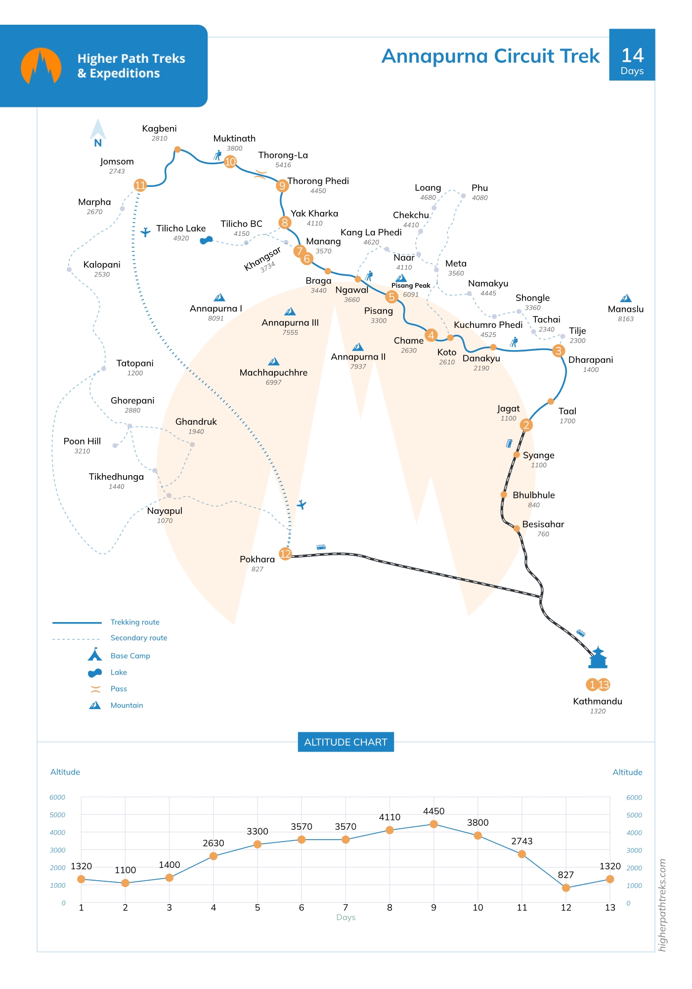
Your Start Date is the day you land in Nepal, and your End Date is when you fly home.
If the set Annapurna Circuit Trek group dates don’t suit your schedule, we can offer alternative dates upon request.
I recently did ACT with Higher path treks. Pasang and Dorje were our guide and Porter respectively. Both were very helpful and friendly. Pasang guided us right from how to hike on high altitude trails without getting tired to helping us putting micro spikes and then guiding us on downhill icy trails. It was an amazing experience. It was a memorable trip. Looking forward for the next adventure with Karma and co.
The Annapurna Circuit Trek with Higher Path Treks & Expeditions was an incredible 14-day adventure through diverse landscapes, from lush valleys to high mountain passes. Everything was well planned and smoothly managed. Karma Sherpa’s expertise and steady leadership made the journey safe, comfortable, and deeply enjoyable. A truly memorable Himalayan experience from start to finish.
The Annapurna Circuit Trek is a renowned trekking route in the Annapurna region of Nepal, known for its diverse landscapes, stunning mountain views, and cultural experiences. It typically circumnavigates the Annapurna massif, starting from Jagat and ending in or Pokhara. The trek crosses high mountain passes, lush valleys, rice terraces, and diverse ethnic villages, offering a complete immersion into the natural and cultural richness of the Himalayas.
The trek usually takes around 12-17 days, depending on the specific itinerary and trekking pace. It involves daily hikes of 5-7 hours on varied terrain, including steep ascents and descents, with ample time for acclimatization and exploration of villages along the route.
Altitude sickness is a concern as the trek reaches high altitudes, including Thorong La Pass (5,416 meters). The itinerary includes gradual ascents with built-in acclimatization days in villages like Manang and Yak Kharka. Trekkers are advised to stay hydrated, maintain a steady pace, and listen to their guide's recommendations.
Risks include altitude sickness, variable weather conditions (especially during the monsoon season), physical strain due to long hiking days, and potential for injuries on rugged terrain. Proper preparation, including physical fitness and acclimatization, is essential for a safe and enjoyable trekking experience.
Highlights include crossing Thorong La Pass with panoramic mountain views, exploring diverse landscapes from lush subtropical forests to arid alpine regions, visiting ancient Buddhist monasteries and Hindu temples, and experiencing the unique culture and hospitality of Gurung, Thakali, and Tibetan communities along the route.
The best times are during the pre-monsoon (March to May) and post-monsoon (September to November) seasons. These periods offer stable weather, clear mountain views, and comfortable temperatures for trekking.
You will need two main permits: the Annapurna Conservation Area Project (ACAP) entry permit and the TIMS (Trekkers' Information Management System) card. These permits can be obtained in Kathmandu or Pokhara before starting the trek.
Both options are possible, but many trekkers opt to join a guided tour with a reputable trekking agency for safety, navigation, and logistical support. Guides provide valuable local knowledge, arrange permits, accommodations, and ensure a smoother experience throughout the trek.